About
Mid-Atlantic Drones: professional photography & videography, specialists in flight restricted zones and experts at aerial drone services.
If you need professional content and media in and around DC, MAD are experts in aerial drone services and are unrivalled at gaining access to flight restricted zones. Founded by two fixed wing aircraft pilots with over 30 years of experience in photography and videography as well as multiple content and media awards, our passion and astute knowledge truly do set us apart. No one can compete with our access to the DC Flight Restricted Zone (FRZ) and our ability to get FAA authorization and acceptance of waivers and permissions.
Founders

Luisa Winters
Luisa brings a unique background to droning she is a certified Private Pilot and a Commercial UAV Pilot and has been involved with video production and cinematography for over 30 years. Having spent years flying, Luisa’s priority is safety. It is this safety mentality that make Luisa’s missions successful: from preparation and planning, FAA Authorization and client expectation to flying and finally, post-production. Luisa shoots exceptional UAV footage that can be incorporated in your projects with ease.
Luisa is certified for night drone operations and holds a night flight drone authorization (waiver) from the FAA. Additionally, she holds aviation certifications from the FAA and Unmanned Safety Institute, Luisa is a Certified Electrical Thermographer, Level 1.
Luisa, a native of Chicago, spent most of her childhood in the Dominican Republic. She graduated in 1987 from the Johns Hopkins University in Baltimore, Maryland. Shortly before graduation, Luisa started working as a videographer in the Baltimore area. Since then, Luisa has been involved in Video Production and Post-Production. Today Luisa serves as a consultant for NBC, CBS, Showtime, Fox News, Adobe, just to name a few.
Within the video industry, Luisa is a well-known figure, a winner of many technical and artistic awards. She is a frequent speaker at NAB, IBC Holland, Government Video Expo, NYC Drone Film Festival, Interdrone, and many others. She is an international celebrity in the video production and post-production world, and examples of her training can be seen in Lynda.com and LinkedIn training, and Total Training.
Luisa is a certified instructor with the Unmanned Safety Institute and an Adobe and Apple Master Instructor.

Mike Sobola
Mike’s background as a Private Pilot, combined with his experience as a TV and Video Producer allows him to bring a unique approach to his aerial imaging projects. His methodical planning and collaboration ensure that each mission achieves its ultimate objectives. First-hand skill and familiarity flying major construction sites gives him the skill and proficiency to capture aerial data and images safely and efficiently.
His flight experience includes Hex copters, quads, fixed gear and retractable platforms in single-pilot and dual-operator configurations. He has more than 700 hours flight experience over multiple platforms including the Freely Alta Hex copter, the Inspire I Pro, the Phantom 4 RTK, the Phantom 4 Pro, the Yuneec H520 and the Phantom 3 Pro.
Mike is certified for night drone operations and holds a night flight drone authorization from the FAA and has been able to obtain FAA and TSA clearance for multiple flights into the DC Flight Restricted Zone or “NFZ”.
Mike spent the formative years of his career living and working in New York City and is now based near Washington, D.C. He has written and produced shows airing on NBC, CBS, HBO, and Discovery, and worked as Lead Producer at The Travel Channel in its early days. He has also had Writer/Producer roles with several companies, including Atlantic Creative and Moon dog Entertainment. He was Executive Producer in Charge of Development and Production at Moondog and served as Showrunner of the 26-part series “Techknowledge” for Discovery Science.
Mike has a degree in Radio, Television and Film from the University of Maryland and a Certificate in Filmmaking from New York University. Trust Mike to get you the drone footage that you need!
Aerial Drone Services and Expertise


Thermal Imaging & Video

We are certified thermographers and have the Three- E’s (expertise, experience and equipment) to get your job done right the first time.
Drone-assisted inspections save you time and ensure a comprehensive task is completed with higher accuracy.
We are experienced pilots and have worked extensively across many sectors doing inspections such as Solar Panels, Roofs, Cell Towers, Structural Damage, Building Envelope Integrity, Insurance and many more!
We are confident we can meet any of your thermo needs as we have a certified thermographer in our team. Zenmuse XT for high quality Thermal IR reports.
Contact us today and challenge us to show you how we can save you time and money by assisting with drones.
Real Estate Marketing
 Great content really pushes your marketing further.
Show off the best of your properties and houses for sale or rent, with custom-filmed aerial photography and videos. Aerial Photography and video, allow you to meticulously plan every shot and piece of content you want us to capture, ensuring your marketing can showcase the best attributes of your property. It’s also different, something fun and more distinct than your traditionally shot static content used in the property space.
If you want your marketing to stand out, you need your content to be exciting.
If you are a realtor, real estate agent, working in commercial real estate; or sale by owner, contact us directly so we can plan how to best showcase your property, making listings sell more quickly and easily.
We cover areas in Maryland, Virginia, Pennsylvania, and Delaware.
Night Time Drone Flight
 While flying drones at night can be challenging, there are legitimate reasons for night flight. It’s not just for aesthetic reasons and cinematography, but for functional ones too. Take inspections, most of these are conducted at night to garner better results and allow for a smoother process. It’s important to note that night time drone flying is no simple task. You need someone with experience and a depth of knowledge to ensure it is done safely and doesn’t become a dangerous exercise. We’re MAD about flying at night and permission to do so legally because of our consistently professional approach.


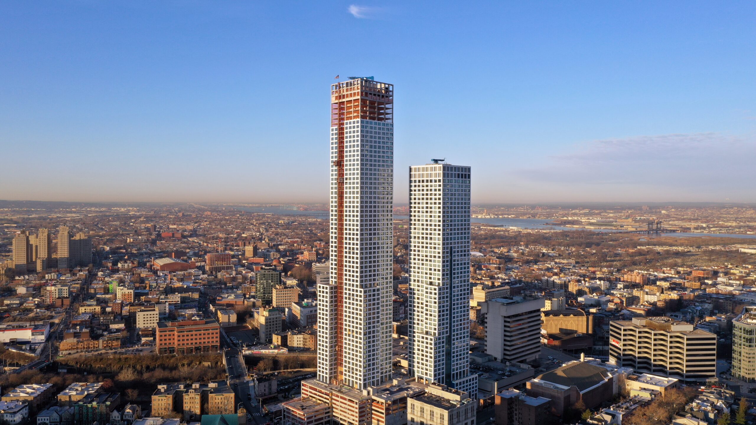
Construction Drone Mapping
 Construction Drone Mapping is one of our specialities as we’ve been flying construction sites for many years. We understand the needs of the clients and what they require from drone construction mapping. Flying, reviewing and delivering necessary data for your construction progress gives you information that can alert you to trouble before it starts.
Mid-Atlantic Drones’ extensive experience flying construction sites gives it superior expertise and knowledge of actual working conditions and mission contingencies, assuring optimal production of deliverables which surpass the client’s expectations and desires. Such expertise allows Mid-Atlantic Drones to provide their drone services in an efficient and cost-effective manner, making their clients’ ‘bottom line’ more profitable.
The use of drone data and precise Ground Control Points (GCPs) will save you and your organization time and money. We’ve been flying long-term construction sites, on a weekly basis, for several years. These results have proven invaluable to our clients, which is why they keep on hiring us for subsequent drone mapping projects.
Regular drone flights, for the purpose of surveying and mapping, allow consistent reports of progress and accuracy. This is done safely and efficiently because the drone flies outside of the range of any debris or construction equipment danger, and you can compare results from week to week. Our clients find this mapping frequency very important in their regular workflow.
We can fly in restricted airspace so you can get the results of drone mapping when you need it. It is in our Standard Operating Procedures (SOP) to bring different drones to your site, ensuring that even in the most difficult of areas, we’ll still be able to deliver your map on a consistent and reliable basis. We have backups, and we have backups for backups.
We plan your drone mapping flights keeping in mind the following:
- Safety (always and foremost)
- Efficiency
- Collaboration
- Workflow
- Results
Save time, money and reduce waste with pre-bid & in-progress construction site aerials. Planning, flying and analyzing Mid-Atlantic Drones offer the complete package.
Our services include 2D and 3D High-Resolution Maps & Volume Measurements, Vector Overlays, Thermal Inspections and much more. RTK, and high precision survey GCPs are also available.
Mid-Atlantic Drones covers most locations in Maryland, Washington DC and Virginia.
We used the Emlid Reach for precise positioning of our Ground Control Points (GCPs)
Free Estimates
We all know the saying “nothing good is ever free”. Well, at MAD we like to challenge some of these old norms.
We can discuss any of your drone services’ needs in a free consultation to make sure we are a good fit.
Contact us and see what a difference our committed team makes for your bottom line.
Mid-Atlantic Drones have been doing this for years – aviation is our livelihood and passion! Methodical planning and collaboration with you, our client, ensures that each mission will get to its ultimate objective: your satisfaction!
Professional Photography & Videography DC
We have won two Emmy Awards, both for work done with Maryland Public TV.
“Water From The Air” was a really exciting project that we worked on. It will sound unbelievable, but the entire piece was shot with a drone. Meticulous planning was required to keep the storyline alive, this had to be thrilling / engaging content, so we had to make sure we weren’t “just flying around getting pretty shots”; we had to keep the narrative going and make sure there was a constant connection, a golden thread if you will.
It was an amazing experience, one I would love to have again.
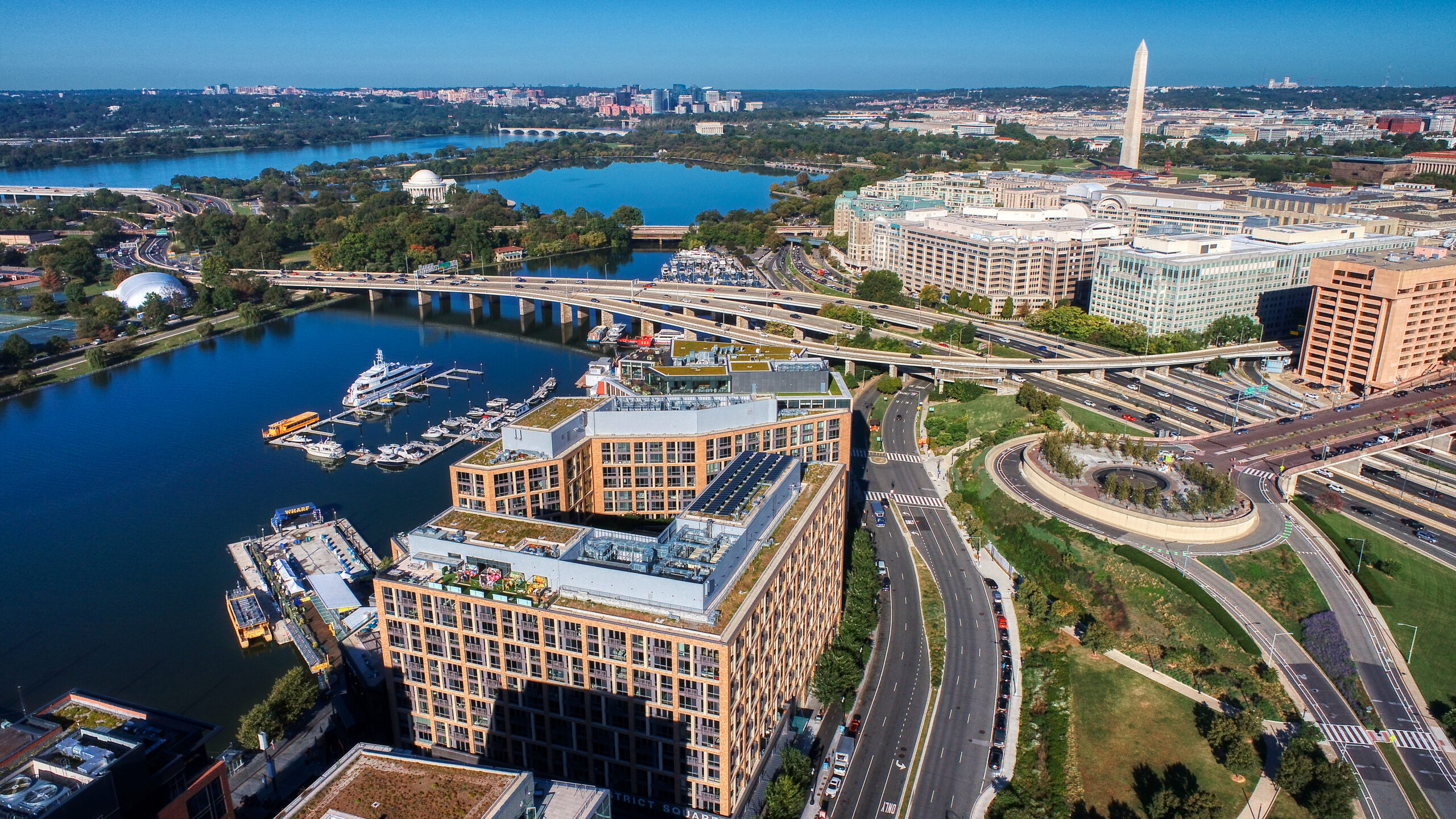
Flight Restriction Zone Specialists

Flight Restricted Zones
Contact us before thinking you cannot get the clearance to fly. Let us try!
Flight restricted zones are areas which require special permissions to fly in. This is so we can conduct drone operations safely not just for us, but for the general public as well.
Due to the secure nature of some of these places, we often require the hiring of extra crew and personnel (including law enforcement officers) during the flight missions. Again, this ensures that everyone is safe.
We have substantial experience navigating. The complicated process of obtaining permissions for flying in these highly controlled and restricted areas. These areas include downtown Washington DC and nearby suburbs. Also, our experience as manned aircraft pilots allows us to communicate easily with aviation officials and other personnel. It is due to this that we can effectively gain access to difficult areas.
Our background and track record have garnered trust from approving aviation officials that translates into successful airspace applications and approved missions for clients in flight restricted zones and controlled airspace. Having the confidence of the organizations that grant permission to fly in critical areas guarantees that your drone needs will be successfully fulfilled throughout all phases of production.
Restricted Zones Include:
- Any area within the DC Flight Restricted Zone
- Designated Critical Infrastructure (such as bridges, dams and power plants)
- Military Operating Areas
- Prohibited Airspace noted as “P-xxx” on aviation charts
- Sporting Events
- National Parks
FAA Authorization in DC
FAA Authorization in DC is difficult to obtain. We always recommend using a specialist, someone with a track record and the right relationships already in place. The paperwork process is complicated, it takes extensive research and is incredibly time consuming just to put together. The processing of this paperwork is very thorough and a decent amount of time passes before you get feedback. This makes getting paperwork right the first time critical if you need to meet deadlines. Few things are more frustrating than sending paperwork off, waiting an age for feedback and being told you have to restart the entire process because you used x’s and not circles.
Use someone you can trust.
Our partners on the regulatory side frequently comment on MAD having one of the best acceptance rates.
Don’t assume you can’t fly in an area, challenge us to get the permissions we need.
